Carolina Beach State Park
 |
| Sugarloaf Dune with Sand Live Oaks circa 2010 |
Carolina Beach State Park is a 761 acre park located on Pleasure Island in New Hanover County. It is the only state park in the region with Lake Waccamaw being the next closest park, and is also one of the smallest parks. Carolina Beach is popular with hikers, campers, and birdwatchers with its trails being easily accessible, and only a short distance from Wilmington. The site is known for its biodiversity with a mix of coastal oak-hickory forests, pine barrens, estuarine marshes, pocosins, and wooded swamps, and is home to endemic plants such as Venus Flytrap, as well as more widespread species such as Yellow Pitcher Plant, and Grass Pink Orchids. Despite its small size, the park is home to many woodland, and estuarine animals including White Tailed Deer, Grey/Red Fox, and various species of birds, butterflies, amphibians, and reptiles. For birdwatchers, the best time to visit this site is during the spring and autumn when songbirds, wading birds, and birds of prey are passing through the region on migration, with Pleasure Island (including Fort Fisher) featuring one of the highest species counts in the region.
Overview
Carolina Beach State Park is located along US 421 (Dow Road) just north of Carolina Beach and is bordered by suburban developments on two sides, the Cape Fear River to the west, and forested landscapes to the south. The park has approximately nine miles of hiking trails with most of them being easy to walk, and well maintained. The site's ecology is diverse with dozens of plant communities and ecosystems nestled within a small area. The landscape can rapidly change from sandy shores along the Cape Fear River to oak-hickory forest, pine barren, brackish marsh, pocosin bay, and hardwood swamp within a short distance. The dunes on the western side of the park creates a hilly landscape with many areas being reminiscent of a deciduous or mixed forest in the Piedmont. The park has eight trails plus a fitness trail across Dow Road that is wheelchair accessible.
Ecology and Geology
 |
| A depression pond that has become a grassland during a dry spell (2011) |
 |
| Early successional habitat with an Eastern Towhee, Oct 18th, 2021, Sand Live Oak Trail. |
Woodlands: Carolina Beach State Park is dominated by maritime forests, and estuarine ecosystems, and is a good example of old-growth forests along the coast. Like many coastal forests, the woodlands are dominated by oaks, hickories, pines, and red or white cedars with a brushy understory of myrtle, hollies, huckleberries, fetterbush, and various herbaceous plants. However, not all of the forests are alike with a short walk along any of the trails revealing dramatic changes in the plant community and geology. Some forests are dense with evergreen or semievergreen trees of medium height. Other forests may have tall deciduous trees with cathedral-like canopies, or may be open woodlands with trees barely 3m (10ft) tall (resembling small bonsai trees). Pine and oak barrens dominate the interior regions of the park with these areas containing open parklike settings with either grassland, or open sand under the trees. The swamps are mostly made up of hardwoods such as tupelo, sweetgum, red or silver maple, sycamore, and water oaks with Titi, buttonbush, and other shrubs filling in the understory. These forests often flood during heavy rains while the pocosin bay habitats contain dense stands of shrubs with Pond Pine, White Cedar, or Pond Cypress serving as the canopy trees. Almost all of the woodlands are maintained by periodic fires which the park conducts on rotating schedules, while tornados and hurricanes can topple large sections of forest, creating meadows, shrublands, and brambles. The forest ecosystem within Carolina Beach State Park is diverse with bird and animal life including forest interior species, although its breeding species pales in comparison to inland forests (or even other forested areas within New Hanover County).
Wetlands and Estuaries: Carolina Beach Park sits along the Snow's Cut Channel and the estuary of the Cape Fear River and is bordered by brackish marshes along its western edge. These wetlands are mostly dominated by Spartina grass, sawgrass, and other grasses although some freshwater sections contain cattail, bulrush, and sedges. The marshes along the Oak Toe (Blue) flood during high tide and are good spots for fiddler crabs, wading birds, rails, and marsh-dwelling animals, as well as various fish. The trails provide many opportunities to view the Cape Fear River where seabirds, pelicans, wading birds, and occasionally dolphins may be seen in or around the river. At the center of the park near the Flytrap Trail are several peatland ecosystems that contain carnivorous plants such as the Venus Flytrap, Yellow or Purple Picher Plant, and Bladderwort, as well as orchids, sedges, and flowering shrubs in the heath family. When flooded they serve as breeding habitats for chorus and grass frogs.
 |
| Cypress Pond in its flooded stage (July 5th, 2021) |
 |
| Pond Pines and Pond Cypresses in the middle of Cypress Pond |
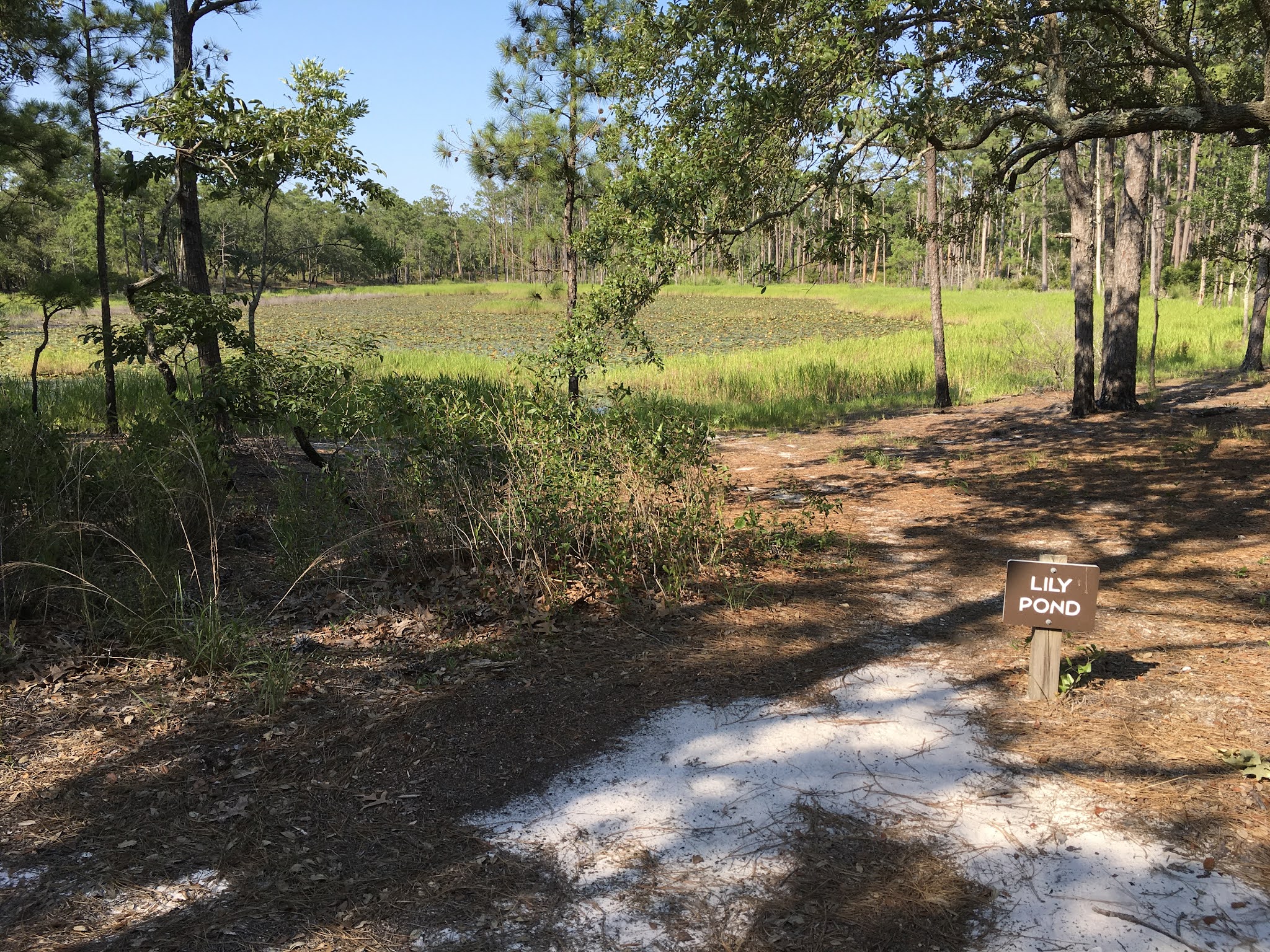 |
| Lily Pond with splatterdocks (same pond as photo from 2010 |
Ponds: Carolina Beach has several vernal ponds that are nestled into forests and pinelands with many of them resembling Carolina Bay Lakes. The largest pond is the Cypress Pond which is located on the southern section of the park, while Lily Pond, and Grass Pond are smaller. Each of the ponds have their own ecosystems with Cypress being large enough to host waterfowl, while Grass and Lily Pond has aquatic plants, frogs, and wet meadows. They become grasslands when they are dried up. The ponds are all along the Sugarloaf Trail and contain unique plants, while the lack of fish allows frogs such as Barking, Squirrel, and Pinewoods Treefrog to breed, as well as many dragonflies. In addition to the freshwater ponds, the park has tidal creeks, and lagoons that provide breeding habitat for fish, blue crabs, and marsh birds.
Geology: One of the most unique features of Carolina Beach State Park are the ancient sand dunes located along the Cape Fear River. Sugarloaf Dune is one of the highest points in New Hanover County. Beyond the main dune, there are a series of trails that wind through smaller hills and slopes with steep
"valleys" and ravines. The sand dunes give the landscape the look of a Piedmont or low-elevation mountain forest with some plants communities that are unique to the area. The rest of the park is mostly flatlands with sandy soil (with some areas being arid-like), while depressions, marshlands, and creeks feature more mesic (moist), soil. Some manmade structures also exist including those associated with the creation of Snow's Cut Channel, and some Civil War earthworks.
 |
| White Tailed Deer along Swamp Trail, circa 2010 |
Wildlife: Carolina Beach State Park is home to a variety of animals including most of the major forest and marshland species. During a visit to this park you can encounter White-Tailed Deer, Grey or Red Fox, Muskrats, Raccoon, Opossum, and possibly a beaver or skunk, though most mammals are nocturnal or are active on overcast days. You are not likely to find Black Bear or other megafauna although they do occasionally visit Carolina Beach by swimming across the river or Snow's Cut and are rather common in Brunswick, New Hanover, and Pender Counties. Grey and Fox Squirrels can be spotted in any habitat within the park but are not nearly as numerous as on the mainland or in New Hanover County (Fox Squirrels are generally more abundant in open forests with oaks and pines).
The park hosts a wide variety of reptiles including dozens of snake, turtle, and lizard species. The Six-Lined Racerunner is among the most iconic species of the Pine Barren, Pine Savanna, and Sandhill Forest ecosystems and is considered to be one of the fastest reptiles on Earth with this red and blue lizard capable of attaining speeds of 37kmh (20mph) while running. You can also find Eastern Fence Lizards, Green Anoles, Five-Lined and Broad-Headed Skinks, Eastern Glass Lizards (also known as Slowworms), and Eastern Box Turtles. Most snakes at the park are nonvenomous with Black Racer, Gartner Snake, Rat Snake, Red-Bellied Water Snake, and Green Tree Snake being numerous. However, there are Cottonmouths in the swamps and peatlands habitats, while Copperheads are fairly common although most snakes will avoid direct interactions with people (and leave when they hear footsteps). The park also hosts the rare and declining Coral Snake, the Pigmy and possibly Diamondback Rattlesnake which again are easily avoided.
As for insects you will see a myriad of butterflies, moths, beetles, truebugs, dragonflies, and native ants with almost all of them being rewarding to find and beneficial. Butterfly watchers can find Spicebush, Black, Tiger, and Palamedes Swallowtails, Monarchs, Viceroys, Sulphurs, Red-Spotted Purples, Morning Cloak, and Gulf Fritillary Butterflies, as well as Luna, Imperial, and various Sphinx Moths during the spring, summer, and autumn. Other interesting finds include stag beetles, Green Tiger Beetles, Rhinoceros Beetles, dung beetles, Florida Harvester Ants, and the giant Swamp, Shadow, and Green Darner Dragonflies (which can reach 10-13cm 4-5" in length). As for the "bad" insects, there are Saltmarsh and Floodwater Mosquitos near the marshes and swamps, Deerflies and Black Horseflies in the Pine Barrens, and the possibility of ticks or chiggers if you go off-trail. However, from my experiences, the mosquitos and biting flies are not too bad and I have been on many hikes with little or no insect activity. The best ways to deal with biting insects is to wear long pants, white socks, and closed shoes, use repellents if desired, and to avoid going off trail or into brushy areas (and to check socks for ticks, fleas, or chiggers before leaving). Insects are also more of a problem around dawn or dusk, or if it is rainy and overcast, and diminish from November to March.
Trail Overview
 |
| Sugarloaf Trail, circa 2010, a informational kiosk was added after 2018-19 |
Sugarloaf Trail (Orange Circle): Sugarloaf is the longest trail at the park at 4.8km or 3mi and extends from the Marina parking area and makes a circuit through most of the park. This trail is also one of the most challenging sections as there are some sizable hills and uneven terrain although compared to hikes in Appalachia or even some Piedmont and coastal sites it is still easily traversed by most people. Those who climb Sugarloaf Dune are awarded with a open vista of the Cape Fear River, while some of the other hills allow visitors to view the treetops from above. Sugarloaf Trail traverses many ecosystems and plant communities. From the Marina, visitors get a taste of the beach with a sandy shoreline bordered by dry meadowland and scrub forests. Many of the Sand Live Oaks, Junipers/Red Cedars, and Pines are only 2-4m (6-15ft) tall and look like miniature versions of the larger trees you would see inland. These scrublands also remind people of places like Arizona, New Mexico, or Southern California where mesquite, acacia, and chaparral, as well as local oak species create a similar landscape.
Further south, the habitat transitions from scrubland to brackish marsh, before entering a section of pine-oak barrens with sandy soil, Wiregrass, Prickly Pear Cactus, and low-growing shrubs. While you will not see flytraps in these xeric (dry) soils, there are lots of unique plants and animals within the Sandhill Forest Ecosystem. Along other parts of the trail including on Sugarloaf itself, the landscape changes again to pine-oak forests where majestic Live Oaks, Laurel Oaks, and Longleaf/Shortleaf Pines tower 18-24m (60-80ft) above the trail, creating a "vaulted ceiling, while the understory can be shrubby, or open. The hills and slopes contain many plant communities while burn areas, windthrows (areas where tornadoes straight-line winds, and hurricanes toppled sections of trees), and marshes provide openings for grassland or shrubland species. This area is a good spot for birdwatching with the forests being home to four species of woodpeckers, Painted Buntings, Brown Headed and White Breasted Nuthatches, Eastern Towhees, Pine, Yellow Throated, and Prairie Warblers, and numerous species of songbirds during spring or autumn migration.
The trail changes again to the south with it returning to pine barren before giving way to classic Longleaf Pine Savanna with its characteristic grassy understory (reminiscent of a prairie in the Midwest). The trail passes all three of the natural ponds/bay lakes including Cypress, Grass, and Lily Pond which as described above are freshwater ecosystems that can host frogs, wading birds, shorebirds, and waterfowl when flooded, but become grassland when they dry out. The northern and eastern section of the trail passes through more pine savanna and grasslands including the area by the Flytrap Trail, crosses the access road and parking lot nearby. The remainder of the loop goes through bottomland and swamp forests where Red Eyed or Yellow-Throated Vireos, Acadian Flycatchers, Yellow-Throated, Summer Tanagers, and Swainson's Warblers are present and you might come across a deer, one or many snake species, or some unique plants. The trail ends back at the marina parking lot after passing through at least twenty different ecosystems and plant communities. This is my favorite trail and you can access most of the other trails including Swamp, Oak Toe, Sand Live Oak, and the Campground Trail from this loop.
 |
| Swamp Trail and Bottomland Hardwood Forest July 5th, 2021 |
Swamp Trail (Red Circle): This 1.2km (0.75mi) trail extends from the Sugarloaf Trail and passes through some examples of floodplain forests, pocosin habitats, and some sections of brackish marsh. This trail is easy with the landscape being flat and wooden walkways being installed in areas where flooding is an issue. Swamp Trail can be buggy however although it is worth a visit. Along this route you will see mature and old-growth stands of swamp forests with Sweetgum, Tupelo, Pond Pine, Bald/Pond Cypress, and various shrubs such as Titi, Buttonbush, Elliot's Blueberry, along with numerous wildflowers from spring through autumn. The forests are also high-value birdwatching sites with Summer Tanagers, Yellow-Throated Vireos, Swainson's Warblers, Barred Owls, and Wood Thrushes being among the many possible species along with the more commonly encountered chickadees, cardinals, Common Crows, Blue Jays, Carolina Wrens, Northern Parulas, and Yellow-Throated Warblers of our area. The edges and grasslands may host other species such as Painted and Indigo Buntings, Chipping Sparrow, and various hawks. While snakes are present and alligators could visit any wetland in New Hanover County, the trail is well-marked and most reptiles will avoid interactions with people. This is a good beginner trail and is an easy way to get to the Flytrap Trail from Sugarloaf. There are also primitive campsites available for groups.
Flytrap Trail (Orange Diamond): The Flytrap Trail is a 0.8km (0.5mi) loop that is wheelchair accessible and is a good beginner trail for new visitors. The trail's main attraction are the carnivorous plants that grow in the bogs and peatlands along the path, including the Venus Flytrap, Yellow and Purple Picher Plant. You will also see many kinds of wildflowers and shrubs unique to Longleaf Pine Savanna, and Pocosin Bay Swamps including many orchid species, milkworts, milkweeds, meadow-beauties, and during the autumn, asters, blazing stars, and coreopsis. These plants also make this section a good spot for butterfly watching with Tiger, Spicebush, and Palamedes Swallowtails being the most common species during the summer months while Monarchs, Painted Ladies, and Sulphurs are abundant towards the autumn. Birds are the same as the other trails with Summer Tanagers, Pine Warblers, Indigo Buntings, and Brown Headed Nuthatches being an guarantee during the summer months, along with woodpeckers. Along with the Sugarloaf and Oak Toe Trails, the Flytrap Trail is a easy place for newcomers to birdwatching or photography as the open canopy, and low vegetation brings birds closer to the ground and makes it easier to locate them as they sing.
 |
| Atop a hill along Sand Live Oak Trail this area resembles a Piedmont Forest. |
Sand Live Oak Trail (Yellow-Green Diamond): The Sand Live Oak Trail is a 2.4km (1.5mi) trail that runs along the Cape Fear River and its estuary and branches off Sugarloaf Trail from both ends. This trail crosses into federal lands which covers much of the western side of Pleasure Island due to the safety zones associated with Sunny Point Military Terminal and the Brunswick Nuclear Plant. These protected areas are closed to development and extend the natural corridor beyond the boundaries of the state park. Along the Sand Live Oak Trail you will continue to weave through ancient sand dunes and former earth works with some sections of the forest being mature (it is possible that some sections may be "Virgin Forest" based on the landscape features). Like Sugarloaf, this trail does involve some hill climbing and some sections may be uneven, or somewhat overgrown, although it is still an easy hike. Among the oak-hickory forests and small sections of pine barren, you will get glimpses of the estuary, pass along healthy spartina and sawgrass marshes, and early-successional habitat created by windstorms/tornadoes, or trees that were killed by saltwater intrusion. The birdlife is similar to Sugarloaf although the marshes and estuary habitats also host species such as Little Blue and Tricolored Heron, Clapper Rail, Marsh Wren, while terns, pelicans, osprey, and Bald Eagles can be spotted over the river itself. In the shrubland and treefall areas, you may come across Blue Grosbeaks, Field Sparrows, Indigo and Painted Buntings, Chats, Prairie Warblers, Grey Catbirds, and Northern Mockingbirds (birds normally associated with powerline cuts, suburbs, or old pastures).
 |
| Burn area around Flytrap/Campground Trail around 2011, today this is a moist savanna |
Campground Trail (Blue Circle): The Campground Trail is a 1.6km (1mi) trail that starts at the visitor center and crosses Sugarloaf Trail and leads to the main camping facilities to the north. This easy trail crosses through various habitats including pine-oak barrens/sandhill forests, old-growth hardwood forests, and the showcase ecosystem around the visitor center (which is burned every few years). This section crosses the main road of the park twice and is somewhat popular as it is near the campgrounds and visitor center. Along the trail, you will see various types of birds with spring and autumn migration being the best times to visit this trail. Some of the notable species include Black and White Warbler, Ovenbird, Red Eyed Vireo, Acadian and Great Crested Flycatcher, and Pileated Woodpecker, with the trail being one of the better places to spot migrating warblers, vireos, and woodland thrushes (Swainson's Grey-Cheeked, Veery, Wood Thrush etc). Another "Easter Egg" associated with this trail is a old water tower and nearby meadow that contains some unique plant species for the area including Lupine (a purple wildflower more common in New England or along the Appalachian Corridor). This plant blooms from late spring through early summer (May-June), and attracts various butterflies.
Oak Toe Trail (Blue Diamond): The Oak Toe Trail is a 0.4km (0.25mi) branch from the Sugarloaf Trail that leads to a wooden overlook and a sandy bank along the Cape Fear River. This trail is somewhat overgrown and occasionally floods during high-tide but is still a easy hike. The ecosystems are the same as Sugarloaf although you will get a good look at the "bonsai forests" as many of the trees are less than 3m (10ft) tall but could easily be 75-100 years old. Sand Live Oaks only grow to about 5m (20ft) and are the smaller counterparts of the Virginia Oak (Live Oaks) which could reach 23m (75ft) and spread out 27-46m (90-150ft). There are also Yaupon Hollies, Eastern Red Cedars, Common Junipers, Red Oaks, Dwarf Palmetto, and stunted Longleaf or Loblolly Pines that grow among the Live Oaks. The trail is named for a species of lichen that grows on some of the oaks. The landscape is mostly sandy and xeric with a mix of low-growing myrtles, huckleberries, junipers, Muhly Grass, Wiregrass, and Switchgrass, and Prickly Pear Cactus. While this type of habitat does not offer much in the way of bird habitat, these scrublands are the preferred habitat of Painted Buntings while the marsh can host rails, Seaside Sparrows, Marsh Wrens, herons, ibis (I saw a Glossy Ibis in September 2021), and a resident pair of Belted Kingfishers. The biggest reward of visiting the Oak Toe Branch is the overlook of the marsh where you can see large colonies of Fiddler Crabs and Mud Crabs during low tide, or various anadromous fish (species that can live in freshwater or saltwater) during high tide. This is also the habitat for the Diamondback Terrapin Turtle as well as the secretive and rare Black Rail (which also uses this kind of marsh). Many people also visit this trail for recreational fishing or to enjoy some quiet time on the "beach" though swimming is not allowed (nor do I recommend it).
Track and Snow's Cut Trail (Red Diamond): The TRACK and Snow's Cut Trail is 1.6km (1mi) trail that extends from the picnic area along the main road to Dow Road and connects to the visitor center and campsites. This trail goes along the Intercoastal Waterway at Snow's Cut Channel and features old-growth hardwood and mixed forests with some trees exceeding 30m (100ft) in height, while other sections contain Loblolly, or Longleaf Pines. The TRACK section of the trail is a self-guided trail for children with associated brochures and educational signage. The Snow's Cut Trail may be one of the better locations for birdwatching as the towering trees and the Snow's Cut Channel serves as a funnel for migratory birds during the spring or autumn. Along with the usual breeders and migrants, people have reported birds such as Black-Billed Cuckoos, Cerulean Warblers, and Scarlet Tanagers during migration, while the forest is old enough for interior species like Yellow-Headed Vireo, Acadian Flycatcher, Wood Thrush, and Ovenbird, though more observational data is needed. The picnic area and its parking lot is a popular birdwatching stop as the open stands of trees makes it easier to see songbirds, woodpeckers (including a resident Red Headed Woodpecker colony), and birds of prey. Like along the western side of the park, the Snow's Cut Channel is a good spot to spot pelicans, seagulls, terns, Bald Eagles, Ospreys, and passing falcons or hawks throughout the year.
Marina Amphitheatre: The State Park maintains a small grassy area near the marina parking lot that features a open field with benches and educational signage around it. At the center of the field is a birdfeeder that is filled with White Millet, along with some scrub-oak species (Sand Live Oak, Red Oak, Water Oak etc). This feeder is used by the Painted Bunting which is a multicolored songbird with males featuring red, blue, and yellow plumages, while the females are the only green-colored finch in much of North America. Several groups of buntings visit this feeder from March to October (sometimes through the winter) with birdwatchers and other visitors being able to photograph, film, or observe the unique species from the benches. The feeder also attracts chickadees, cardinals, House Finches, Pine Warblers and other bird table visitors, while Indigo Buntings and Blue Grosbeaks (more familiar to those who live inland or in residential areas around Wilmington) also visit during migration. In addition to the feeder, the Marina is a good spot to pick up seagull (usually Laughing, Herring, and Ring-Billed Gulls), tern, and wading bird species, glimpse waterfowl or eagles over the lakes, and to observe Tree, Barn, and Rough-Winged Swallows from March to July.
No comments:
Post a Comment